 WhatsApp
Satellite-Powered AgTech Platform
Smarter Farms,
Better Yields.
Powered By Ai.
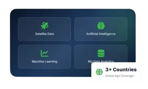
AgriPulseAI is a Zimbabwean AgTech company transforming agriculture through satellite data, artificial intelligence, machine learning, and big data analytics. We deliver SaaS solutions that democratize precision agriculture across sub-Saharan Africa.
80k
Acres Transformed
70+
Crops Supported
7+
Countries Served
Satellite-Powered AgTech Platform
Smarter Farms.
Better Yields.
Powered By Ai.
AgriPulseAI is a Zimbabwean Agtech company revolutionizing farming through satellite data, Artificial Intelligence, Machine Learning, and big data analytics. We deliver SaaS solutions that democratize precision agriculture across sub-Saharan countries.
80k
Acres Transformed
70+
Crops Supported
7+
Countries Served
80k
Acres of Farmland
Transformed
7+
Countries
Served
30-40%
Increase in
crop yeild
70%
Time saved in
Farming Monitoring
10-12%
Reduction in
Water Usage
Satellite-Derived Insights
Harness multi-satellite data to monitor every inch of your farm without physical visits
Near Real-Time Data
Get satellite data within 1 day and pest alerts within minutes for timely decisions
Global Accessibility
Available on web and mobile, serving 50+ countries with localized insights
About AGRIPULSE AI
Revolutionizing Agriculture with Satellite Intelligence
AgriPulseAI is a Zimbabwean AgTech company transforming agriculture across sub-Saharan Africa through satellite data, artificial intelligence, machine learning, and big data analytics. We deliver innovative SaaS solutions that democratize precision agriculture for farmers, financial institutions, insurers, and supply chain stakeholders.
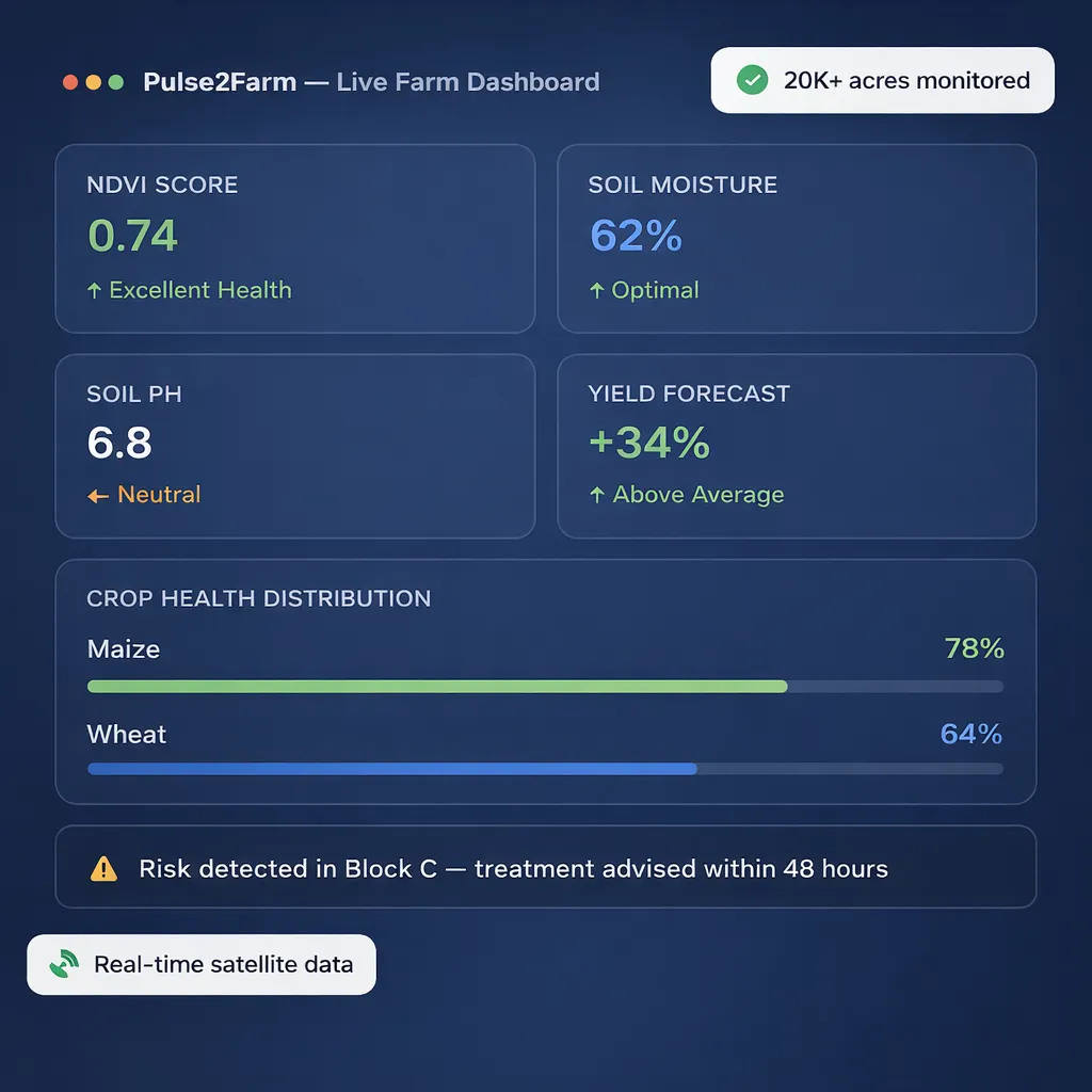
Our flagship platform, Pulse2Farm, delivers near real-time actionable insights across 10+ crops through both mobile and web platforms, enabling smarter farm management and more data-driven decision-making.
Precision Tools for Every Agriculture Stakeholder
Five powerful platforms engineered with satellite technology, AI, and machine learning to serve farmers, enterprises, financial institutions, and sustainability teams.
Pulse2Farm
Increasing Farm Income Using Satellite Remote Sensing
A mobile and web application that revolutionizes farming by providing real-time precision farming information to farmers and agricultural enterprises worldwide.
Soil Health
Pest Alert
Weather
Irrigation
Soil Health — Satellite Soil Testing
Get NPK, pH and SOC through satellite-based soil test reports. Identify nutrient deficiencies instantly without traveling for physical samples.
Pest & Disease Forewarning
Real-time forecasts of crop pests and diseases based on humidity, temperature and agronomic parameters with recommended control measures.
14-Day Weather Forecast
Plan sowing, irrigation, and harvesting with 14-day weather forecasts tailored to your farm location
Crop Calendar
Comprehensive localized guidance on optimal planting, harvesting, and maintenance schedules for 100+ crops with recommended packages of practices.
Irrigation Advisory
Satellite-based precise irrigation advisory. Determine soil moisture deficiency and plan irrigation to achieve optimal yields while minimizing water wastage.
Soil Moisture (SM)
Satellite-based soil moisture estimation. Track moisture levels in each section of your farm to plan irrigation schedules before crops experience stress.
Image Advisory
Instant identification of pests and disease infestation. Upload images of affected plants and receive precise advisory within 3–4 hours.
LSWI — Land Surface Water Index
Satellite-based LSWI estimation to track changes in liquid water content of soil and vegetation, especially in early growing season.
Crop Health Monitoring (NDVI)
Monitor crop health remotely using satellite-derived NDVI to precisely identify problem areas and focus on the most critical field zones.
Pulse4Risk
Expert Risk Assessment for Farms and Properties
Simplify property and farm risk management worldwide. Integrating satellite data for real-time, accurate, and scalable risk information to BFSI institutions and insurers.
Risk Score
Flood Risk
Drought Risk
Rainfall
Farm Risk Assessment
Streamline farm risk management with real-time, accurate satellite data. Fastens loan approval processes for banking institutions.
Risk Score
Comprehensive risk scoring for farms and properties, combining multiple satellite-derived indicators for a unified risk assessment.
Flood Risk Analysis
Near real-time flood risk assessment using satellite data to identify vulnerable areas and estimate potential crop/property damage.
Drought Risk Analysis
Monitor and predict drought conditions using soil moisture indices, vegetation stress indicators, and rainfall pattern analysis.
Farm Monitoring Portfolio
Monitor health of entire loan or insurance portfolios and minimize risk with timely satellite-based alerts and reports.
Property Risk Management
Evaluate property risks globally — weather patterns, drainage information, urban development growth, and prevented sowing assessments.
Crop Yield Estimation
Assess repayment capacity by knowing yield prediction estimates. Vital for lenders and credit institutions making agricultural loan decisions.
Global Coverage
Satellite-based global coverage allowing risk assessment across different regions and countries for investors, insurers, and stakeholders.
Web Portal Access
Pulse4Risk is available as a comprehensive web portal for quick, data-driven decisions by BFSI and insurance professionals.
Pulse4Agric
Agri-Commerce Platform for All Agriculture Stakeholders
A web application transforming crop cultivation by integrating advanced satellite technology with precision, real-time data, and enhanced management capabilities for agricultural enterprises.
Crop Stage
Acreage
Classification
Yield Est.
Crop Stage Analysis
Monitor crop conditions across all growth stages — flowering, fruiting, and ripening — to schedule harvesting and farm activities at optimal times.
Crop Acreage Estimation
Precision acreage estimation providing essential data on the extent of agricultural land under cultivation at regional and national scale.
Crop Health Monitoring
Visualize crop health data at major scale, accurately detecting the extent of damage to specific crops with detailed percentage reports.
Agricultural Crop Classification
Identify different crop types grown in a village, taluk, district, or any regional level for precise assessment of cultivation variety.
Soil Health Analysis
Macro-level insight into soil health including essential macronutrient levels (NPK), SOC, and soil pH across large agricultural areas.
Soil Moisture Estimation
Proactively address drought challenges using satellite data integration to monitor soil moisture and implement targeted cloud-seeding measures.
Crop Yield Estimation
Accurately estimate crop yields empowering farmers and stakeholders with vital insights for optimal harvest planning and resource management.
Supply Chain Intelligence
Estimate farmland planted with a crop and detect exactly how much has been grown to help Agri output companies plan their procurement activities.
Enterprise Dashboards
Comprehensive reports optimized for warehouses, procurement companies, and post-harvest supply chain including cropping patterns and maturity status.
Pulse2Farm Green
Increasing Organic Farm Income Using Satellite Remote Sensing
A mobile and web application supporting organic farming with real-time insights for healthier crops, sustainable yields, and natural farming practices.
Organic Soil
Natural Pest
Sustainable
Irrigation
Organic Soil Health Testing
Get NPK, pH and SOC via satellite. Spot nutrient deficiencies and apply natural, organic inputs to restore soil balance for sustainable yields.
Pest & Disease Forewarning
Alerts farmers to potential pest and disease outbreaks recommending effective organic treatments like neem-based preparations and panchagavya.
14-Day Weather Forecast
Plan organic farming activities — sowing, irrigation, and harvesting — with accurate 14-day weather forecasts for your farm location.
Organic Crop Calendar
Localized guidance on best times for planting and harvesting with recommended organic practices including vermicompost and cow dung application.
Irrigation Advisory
Efficient water management for sustainable organic farming. Identifies soil moisture levels and provides timely irrigation advice for healthy crops.
Image Advisory
Upload images of affected plants and receive guidance on organic solutions — cow dung, panchagavya, neem-based preparations — to protect yield quality.
Soil Moisture Monitoring
Track soil moisture changes over time to plan irrigation wisely and prevent crop stress while avoiding overwatering for healthy organic crops.
LSWI Estimation
Monitor LSWI levels over time to understand soil moisture trends and manage irrigation more effectively in the organic farming context.
Crop Health (NDVI)
Monitor organic crop growth remotely using satellite-based NDVI data. Identify problem areas early and focus attention where it matters most.
MRV Carob Credit
Satellite-Based MRV Solution for Carbon Credits
Measurement, Reporting, and Verification (MRV) framework ensuring credibility and transparency of carbon credit initiatives through satellite remote sensing technology.
SOC Estimation
Credits MRV
Verification
Monitoring
Accurate Measurement
Satellite remote sensing technology to quantify GHG emissions reductions with precision. Every ton of carbon credit based on reliable, verified data.
Transparent Reporting
Detailed and comprehensive reports outlining methodologies, data sources, and overall impact of emissions reduction projects for full transparency.
Third-Party Verification
Independent verification by accredited organizations ensures carbon credit projects meet the highest international standards and protocols
Continuous Monitoring
Ongoing monitoring systems track the long-term impact of emissions reduction projects to ensure sustainable environmental benefits.
SOC Estimation
Advanced satellite technology for accurate and non-invasive estimation of Soil Organic Carbon (SOC) levels for carbon credit quantification.
Global Reach
Satellites transcend geographical boundaries, enabling monitoring of emissions reduction projects in even the most remote global locations.
Vegetation Health (NDVI)
NDVI derived from satellite data helps assess vegetation health directly related to carbon sequestration for precise carbon credit estimation.
Carbon Credit Trading
Calculate emission reductions and convert into carbon credits following standardized methodologies for market integration and trading.
Emission Source Mapping
High-resolution satellite images to identify and map emission sources including deforestation, industrial facilities, and agricultural activities.
Industries We Serve
Empowering Every Agriculture Stakeholder
From smallholder farmers to multinational enterprises, we deliver tailored precision agriculture solutions for every player in the agriculture ecosystem.

Farmer
Get digitized crop solutions through satellite-based monitoring. We support small, marginal, and large farmers to practice precision agriculture from sowing to harvesting.
Soil test reports within minutes — no physical sampling needed
Pest & disease forewarning for timely crop protection
Up to 30–40% improvement in crop productivity
5–10% reduction in agri-input costs
70% time saved through remote farm monitoring
10–12% reduction in water usage

Agricultural Enterprises
Find out how satellite-based technology helps in improving access to collect large-scale data for procurement, supply chains, and enterprise crop management.
Multi-satellite data on crops grown at regional level
Large-scale acreage and yield data collection
Up to 70% accuracy in pest/disease prediction
Supply chain procurement planning and optimization
Break gaps in supply chain infrastructure
Direct link between producers and Agri companies

Agricultural Credit
Creditworthiness assessment of prospective borrowers with real-time satellite monitoring of current cultivation status and yield prediction estimates.
Real-time monitoring of current cultivation status
Yield prediction for repayment capacity assessment
NDVI and soil moisture for clearer fertility picture
Farm-level flood and risk estimation
Faster loan approval through digital assessment
Reduce non-performing agricultural loans

Crop Insurance
Help agri-insurance companies make quick decisions by delivering remotely monitored farm-level information for insured area validation and risk assessment.
Insured area and crop type verification
Satellite-based crop monitoring reports
Faster claim settlement with satellite evidence
Crop sown area and acreage classification
Near real-time climate vulnerability measurement
Adaptable digital tool for risk evaluation

Carbon Monitoring
Track your carbon footprint for thriving fields and sustainable yields. Global near real-time monitoring of soil organic carbon with comprehensive reporting.
Satellite-based SOC level monitoring
Carbon emissions analysis and reporting
No physical soil sample collection needed
Validate regenerative agricultural practices
Instant soil organic carbon reports
Support for agroforestry carbon sequestration

Ready to Transform Your Agriculture Operations?
Join thousands of farmers, enterprises, and institutions already using AgriPulseAI to make smarter, data-driven decisions.
How It Works
From Satellite To Actionable Farm Insight
Our technology pipeline turn ray satellite data into precise, actionable
intellegence delivered directly to your farm, desk and mobile device
Satellite Data Capture
Multi-satellite imagery captures near real-time data from your farm — soil, crop, water, and weather conditions at field-level precision.
AI & ML Processing
Our AI and Machine Learning algorithms analyze billions of data points to extract meaningful patterns, predict risks, and generate precise recommendations.
Insight Generation
Processed data transforms into actionable insights — soil health scores, pest alerts, yield forecasts, risk assessments, and carbon measurements.
Delivery to You
Insights delivered to your mobile app, web dashboard, or integrated API within 24 hours — ready to act upon for maximum farm productivity.
Proven Impact
Most tools give you software.
We give you results.
AgriPulseAI's satellite-powered platform delivers measurable results across every dimension of agricultural operations — from yield and cost to water efficiency and sustainability.
30–40% Increase in Crop Productivity
Precise identification of issues at plant level leads to significant improvements in overall crop yield.
5–10% Reduction in Agri-Input Costs
Targeted use of fertilizers and pesticides based on satellite data reduces unnecessary expenditure.
70% Time Saved Through Remote Monitoring
Remote satellite-based monitoring eliminates the need for physical field visits, freeing up valuable farmer time.
10–12% Reduction in Water Usage
Satellite-based irrigation advisory ensures water is applied only when and where it's needed — more yield per drop.
60% More Accurate Crop Analysis
Satellite-based analysis outperforms conventional crop cutting surveys by 60% in accuracy of crop growth and damage assessment.
80k
Improvement in Crop
Productivity
70%
Time saved in farm
monitoring
60%
More Accurate Crop Analysis
10-20%
Reduction in Water Usage
1 Day
Satellite Data Delivery Time
5-10%
Reduction in Agri-Input Costs
70%
Accuracy in Pest/Disease Prediction
7+
Countries with Active Coverage
Success Stories
Trusted by Agriculture Stakeholders
Real results from farmers, financial institutions, and enterprise clients using AgriPulseAI's precision agriculture platform.

"Since using Pulse2Farm, I've increased my maize yield by 38% and reduced pesticide costs significantly. Getting soil test reports instantly without leaving my farm has been life-changing."
Tendai Moyo
Smallholder Farmer — Zimbabwe
"Pulse4Risk has transformed how we assess agricultural loan applications. We can now validate farm conditions and crop yields remotely, cutting loan approval time by 60% while reducing NPAs."
Amara Khumalo
Agricultural Lending Manager — Regional Bank
"The MRV Carbon Credit platform has given us the transparency and accuracy we needed to participate in carbon markets. The satellite-based verification process is both efficient and globally credible."
Rudo Ndoro
Sustainability Director — Agri Enterprise
Ready to Transform Your Farm Operations with AI?
Join AgriPulseAI today and harness the power of satellite intelligence, AI, and machine learning for smarter, more profitable and sustainable agriculture.
Ready to Transform Your Farm Operations with AI?
Join AgriPulseAI today and harness the power of satellite intelligence, AI, and machine learning for smarter, more profitable and sustainable agriculture.
Get in Touch
Let's Talk About Your Agriculture Needs
Whether you're a farmer, enterprise, financial institution, or insurer — our team is ready to show you how AgriPulseAI can transform your operations with satellite-powered precision agriculture.
+263 778 856 247
Website
www.agripulseai.farm
Get in Touch
Let's Talk About Your Agriculture Needs
Whether you're a farmer, enterprise, financial institution, or insurer — our team is ready to show you how AgriPulseAI can transform your operations with satellite-powered precision agriculture.
+263 778 856 247
Website
www.agripulseai.farm
Revolutionizing farming practices across sub-Saharan Africa through satellite data, artificial intelligence, machine learning, and big data analytics—delivering precision agriculture solutions across 7+ countries.
Products
Industries
Contact
Copyright 2026. AgriPulseAi. All Rights Reserved.
Revolutionizing farming practices in sub-Saharan Africa through satellite data, Artificial Intelligence, Machine Learning, and big data analytics — delivering precision agriculture solutions across 7+ countries.
Products
Industries
Contact
Copyright 2026. AgriPulseAi. All Rights Reserved.